This is one of a series of four self-guided tours across Shetland in search of the filming locations that have graced our screens, inspiring people to visit the isles. This time we explore the locations used in Shetland's North Mainland.

In this tour, we cover a lot of ground, so before you set off, it might be a good idea to check the fuel tank before you leave!

To begin the adventure, leave Lerwick via the north and Holmsgarth Road, passing NorthLink Ferry Terminal and Mair's Pier. Many of the islands' fleet of pelagic and whitefish boats are berthed here. Lerwick's new fish market opened here in 2020 – you may have visited the old fish market during the Lerwick Tour. Join the A970 and follow the signs towards Hillswick.

Leaving Lerwick, you will pass an 18-hole golf course at Dale. This golf course was funded by the oil companies who invested in North Sea oil and constructed the Oil Terminal at Sullom Voe in the 1970s – but more about that later in the tour.

Halfway House

From here, follow the road north for 12 miles until you reach Sandwater Junction, leading to Kergord and Weisdale (on the junction with the B9075) at Sandwater House.

The A970 is the main artery road that runs north to south through Shetland. The house sits alone at Sandwater junction and is known locally as the Halfway House. Please note that this is a private residence, and visitors should not trespass or intrude on the owner's privacy. This house was one of the filming locations during series three of the show. You may remember it as the place where the peculiar artist had a stash of dead animals in his freezer!

Interestingly, the house has always been an important waymarker in times past. Locally, everyone knows it as a kind of landmark – from here, you are pretty much in the middle of Shetland and, one mile north, is the spot furthest from the sea anywhere in the isles – three miles from the sea. In Shetland, you are never more than about a mile and a half from the sea, so it's little wonder that Shetlanders are said to have saat in da blöd [salt in the blood].

The Halfway House was used as a coaching inn, where tired and weary travellers and their horses could bed down and stable their animals for the night. This was also an important place for crofters and farmers – the annual livestock roup [auction] was held in the field to the right of Sandwater that is now a new access road.

This area here is an expanse of peatland – peatlands make up 50 % of the Shetland's landscape. It's hard to imagine a time when Shetland wasn't cloaked in a blanket of peat moor, but if you were to have landed here in Neolithic times – some 5,000 years ago – the landscape would have been very different. With a more temperate climate and lower sea levels, much of Shetland was made up of reasonably good agricultural land blanketed in a covering of low-growing hazel, birch and willow. The introduction of grazing animals and a deterioration in the climate – combined with rising sea levels – put pressure on populations. By the Iron Age, much of Shetland's landscape was covered in blanket peat moor.

Continuing north along this stretch of road – known locally as Da Lang Kames – you will pass the loch of Petta Water. This is an area high in 'trow activity'. Trows are a feature of Shetland folklore. They are creatures, similar to humans but smaller and uglier, who live in the hills – particularly the heathery peatlands inland from the sea – such as here! They would only come out at night to work mischief in the human world. If a trow were to get caught out by the rising sun, it would turn to stone before it could get back to its underground layer. Many of Shetland's standing stones are said to be petrified trows.
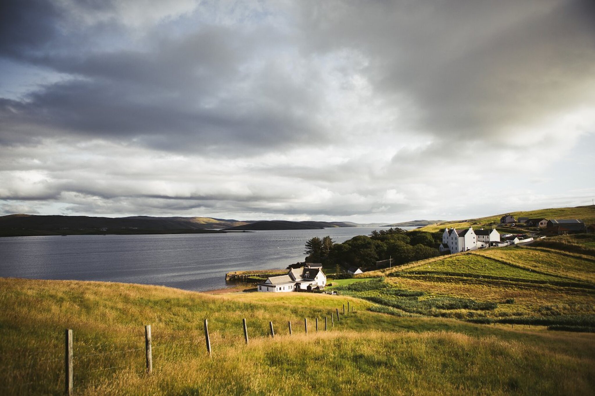
Voe

Continue along the road for a few more miles until you reach the small village of Voe, a picturesque community tucked into the end of a long fjord-like voe, sheltered from the worst of the weather.

Take the B9071 towards Lower Voe. At the pier, park up and have a wander around to stretch your legs. The Sail Loft, now a self-catering camping booth, was used as a filming location in series one. This was where student archaeologist Hattie lived – before she was murdered, of course. It was also used in series three.

The area around Lower Voe is culturally important to Shetland's past. This was where Adie's of Voe was based throughout the 19th and 20th centuries. Think of Adie's like a great big shopping complex – the family-run business had everything from general grocers to a weaving factory selling cloths to all the big fashion houses. There was a fish curing station and associated coopers – and a bakery was established in the First World War to service the 10th Cruiser Squadron based in the area. The bakery today still produces local bread throughout the isles. Be sure to pick up a Voe bannock or a Voe pie on your travels – you won't regret it!

Adie's also produced knitwear that was shipped all over the world. Most famously, the jumpers worn by Edmund Hillary and Tenzing Norgay when they became the first people to conquer Mount Everest in 1953 – if that's not a sign of quality, I'm not sure what is.

Sullom Voe

Head back towards the main A970, turning left towards Upper Voe. Follow the road for a quarter of a mile before turning right on to the A968 towards Toft and Sullom Voe. Drive 11 miles to Sullom Voe, taking the B9076 at Mossbank towards Sullom Voe.

Sullom Voe Oil Terminal was built in the 1970s and has provided economic prosperity for Shetland since its opening. When oil was discovered in the North Sea, and a terminal proposed, Shetland's councillors were keen to ensure a good deal for the isles. Shetland had suffered an economic decline since the end of the Second World War, and many people had been forced to move away in search of work. The council were able to strike a good deal, and for every barrel of oil landed in Shetland, the community got a percentage of the profit. This money was held in a charitable trust fund and has paid for much of the islands' infrastructure, care and leisure facilities, and a vibrant cultural scene.

The oil terminal is tucked away in Sullom Voe, largely hidden from sight. At the time of building, it was the second-largest oil terminal in Europe – following an extension, Rotterdam is now the largest. Oil began to flow at a rate of 800,000 barrels a day along two pipelines from 1978. Today, fewer barrels of oil are landed here, but it is still an essential part of the local economy (oil and gas are worth around 15%).

Sullom Voe and the surrounding Sella Ness docks were key locations in series two and series five – you may remember the Sella Ness area as the caravan park. Access to Sullom Voe is restricted, but it's good to drive to the viewpoint and get a sense of this part of a more industrial Shetland. There are interpretation panels at the site gates detailing the history of the area.

During the Second World War, Sullom Voe was a strategically important RAF base where flying boats were based.

Busta House Hotel

From Sullom Voe, take the B9076 towards Brae (six miles). Brae is the largest town in the North Mainland, and with a school, leisure centre, care centre, garages, shops and pubs, it is a well-served community.

From Brae, continue north along the A970 (towards Hillswick) for a mile, then turn left towards Busta and Muckle Roe. From here, follow the road for 0.5 miles until you reach Busta House Hotel.

Busta is a three-star hotel placed in an idyllic rural location in one of Shetland's most beautiful historic houses, but it also has its own unique ghostly tale to tell.

The earliest part of the house was built in 1588 by the Gifford family, a local landowning family who, in the 18th-century, were amongst the most influential families at the time. With the family's wealth growing, new wings were added to the building, which has all the appeal of any other great house in Scotland.

A wealthy merchant to trade, Thomas Gifford appeared to have it all – a loving wife and 14 children, including four sons, assuring security to Thomas that an heir to the vast estate was waiting in the wings. But, what was to happen in 1748 would shake the family to the very core and change the course of history forever. A boating accident led to the death of all Busta's male heirs, leaving only one illegitimate son – born of a servant, Barbara Pitcairn, and said to be the son of one John Gifford. This scandal caused a hundred-year feud that ultimately bankrupted the estate. The ghost of Barbara Pitcairn is said to haunt the house today.

Busta is a prominent location in the Shetland series. This is the famous Skellwick Hotel of series two and a fantastic place to make a pit stop for lunch before heading on north. They also have a vast whisky selection!

Hillend and the Drongs

From Busta, make your way back onto the main A970 heading north towards Hillswick. Follow this road north for 11 miles. Eventually, the main road narrows, becoming a single carriageway passing through the picturesque village of Urafirth. Just after Urafirth and the 'welcome to Hillswick' sign, look out for the sign marking the road to Eshaness – take this road (B9078) and follow it for a couple of miles until you reach the iconic home of Magnus Bain in series one – Hillend.

Hillend is now an uninhabited traditional croft house of the two-room – but an' ben – design. It overlooks the stony beach below where the body of schoolgirl Catherine Ross was washed up in the first series. Out to sea, there are fantastic views of the Drongs – an impressive set of sea stacks that tower from the sea with a menacing presence.

Many of the scenes for the forthcoming seasons have also been shot here, so stay tuned for that!

Eshaness and the rugged northwest

From here, continue north on the last stretch of the B9078 towards Eshaness. Eshaness is the northwesternmost point of mainland Shetland and is rugged and beautiful. This area is made up of volcanic rocks and was once an active volcano.

On the way, just beyond the Braewick Cafe (which is excellent for local food and enjoys unrivalled views out to sea and towards the Drongs and Heads of Grocken), is the Old Schoolhouse building (marked on Google Maps as an 'Old Post Office'). Take the road to the right, just before the red post box. This road leads to the pier, and the house on the right is Perez's father's house. In real life, this was where Dr Tom Anderson was born.

Dr Tom Anderson (1910-1991) is heralded as the saviour of Shetland's traditional fiddle music. After working away for many years, he returned to Shetland and whilst working as a travelling salesman, he recorded all the traditional fiddle tunes that we know and love today.

Below this house is another location, Freya's croft – which is featured in the Fair Isle storyline of series two.

After exploring the crofts at Eshaness Pier, make your way towards Eshaness and the end of the road. Park at the lighthouse and have a walk around the Eshaness cliff area – interpretation panels will guide you, or you can download the Eshaness Circular walk.

The lighthouse was built in 1929 by David and Charles Stevenson of the famous 'lighthouse' Stevensons. With its 12 metre tower, this was the last lighthouse constructed in Shetland and, until 1974, was manned by a lightkeeper who lived in the accommodation adjacent to the light.

The area around Eshaness is geologically fascinating; the peninsula was formed about 360 million years ago when Shetland lay close to the equator. The cliffs show a series of lava flows dating back millions of years to a landscape of volcanoes, fire and lava.

This area has featured heavily throughout the Shetland series – notably as the fictional Pit of Biddista from the books; bodies have been found, suicides prevented, and many scenic shots filmed in and around the area.

Hillswick

Backtracking along the B9078, return towards Hillswick.

Hillswick Seal Sanctuary – down by the sea, past the local community-run shop – featured heavily in series four. The Seal Sanctuary is a rescue centre for injured or sick seals and otters. Visitors are welcome, but it is best to call ahead to make an appointment.

If you're in need of a cup of tea – or something stronger – pop into the St Magnus Bay Hotel, also known as the Hillswick Hotel. St Magnus Bay Hotel was originally built in the late 19th century by the North of Scotland Orkney & Shetland Shipping Company. The company ran the boat between Shetland and Mainland Scotland, offering 'small cruises' within the isles.

Hillswick Beach is tucked away and hidden from sight of the main road is the perfect place to stretch your legs after a long drive. The beach has fantastic views of the sea stacks and cliffs that dominate the area.

Heylor

Moving on, leave Hillswick and track back along the A970 towards Urafirth. At Urafirth, after the school, take the road leading towards Heylor and Swinister on the left. About a mile up the road, bear left towards Heylor – this is an old fishing and whaling station and is worth the short detour for the views across to Shetland's highest point, Ronas Hill, alone.

Filming for forthcoming seasons has also taken place in this area.

Ronas Hill stands at 450 metres and is classed as a Marilyn rather than the larger Munro or mountain. Ronas Hill is an impressive red granite geological feature called a batholith and features rare Arctic alpines on its tundra-like upper reaches.

North Roe

From here, rejoin the road leading from Urafirth towards Swinister (taking a left and passing a crab factory) – there is no road sign to mark the way, and turning right would return you to Urafirth. This road, which leads to Ollaberry and North Roe, skirts the side of Ronas Voe, a long narrow inlet of seawater, and is a very picturesque drive of several miles, with Ronas Hill to the left. Along the way, look out for peat banks where locals cut peat to provide winter burning for fires.

At the end of the road, take the A970 once more, turning left towards North Roe. After a few miles, you'll see a copse of trees on the right, pass these, and after the stretch of straight road, an uncategorised track leads up the hill to the left. There are no road signs to mark it, and the road is rutted and reasonably steep as it ascends the hill. The road is suitable for most cars but is unsuitable for larger vehicles and campervans.

Collafirth Hill

Follow this road up to the top of Collafirth Hill. This is a great vantage point to enjoy views across Shetland. Collafirth Hill is also the starting point for those who wish to climb Ronas Hill. Interpretation panels explain that this area is a place where rare Arctic alpines grow.

Collafirth Pier

Drive back down the hill, turning left at the bottom. You reach Collafirth Pier, another location used in the Shetland TV series about a mile along the road. This is the pier that the pelagic trawler belonging to the Isbister family was shot at in series two.

Often there's a large trawler, Altaire, tied up at the pier, dominating the area. This was the boat used on the show, and she is one of eight state-of-the-art pelagic boats. Herring fishing has historically been big business in Shetland, and it remains important to the isle's economy today. With a lucrative catch shipped worldwide, from Europe to as far as Africa and Asia. These super-trawlers are the largest boats that fish from Shetland. The fleet, in 2019, landed 69,196 tonnes of fish worth an incredible £64.5 million.

From here, we will wind up the day and let you make your home at leisure – you might want to head back to Eshaness to enjoy the sunset? If you're feeling hungry on the way home, stop at the award-winning Frankie's Fish & Chips in Brae.

Discover more locations from TV's Shetland