By Tom MortonMarch 9th 2017
Tom Morton

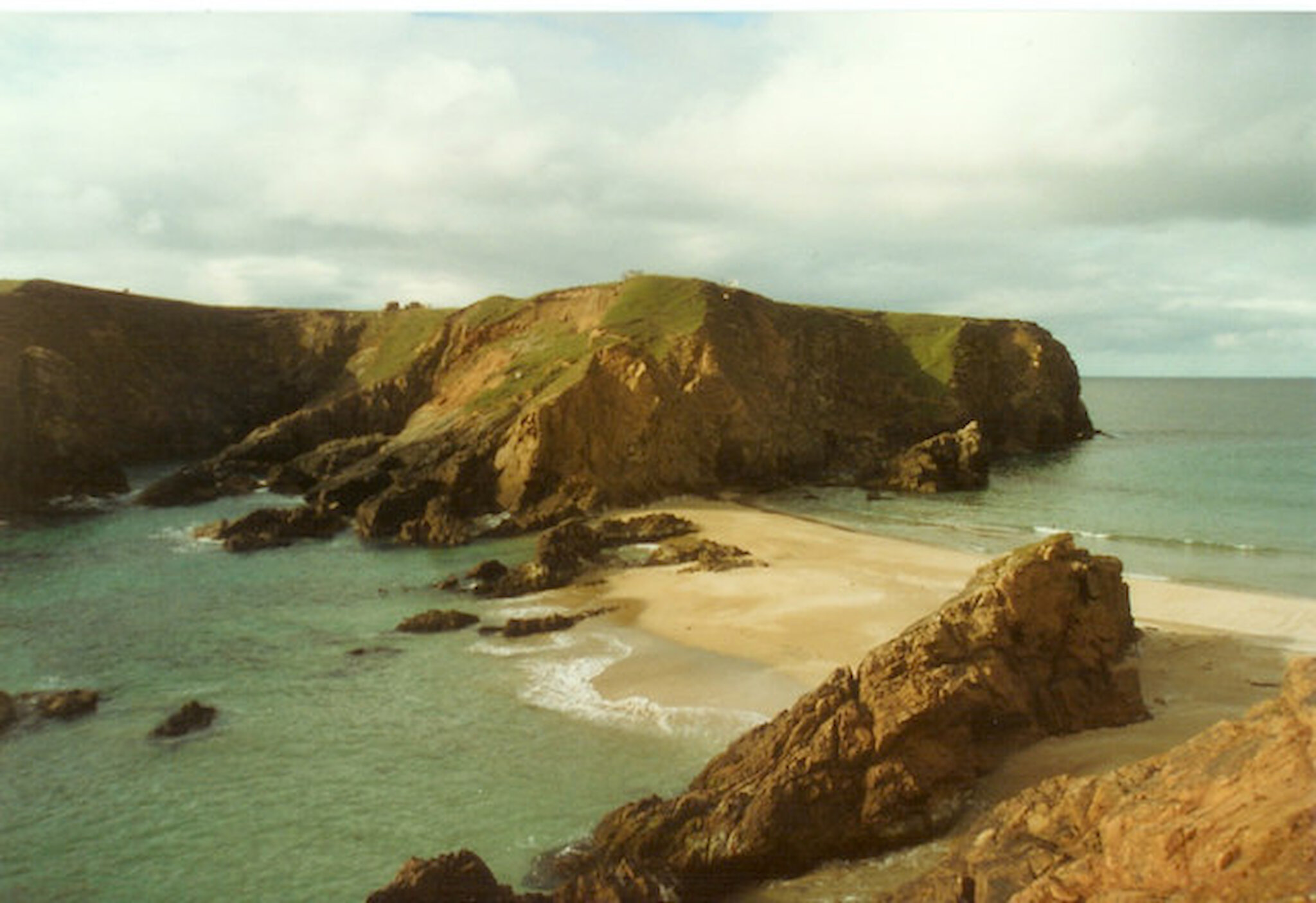
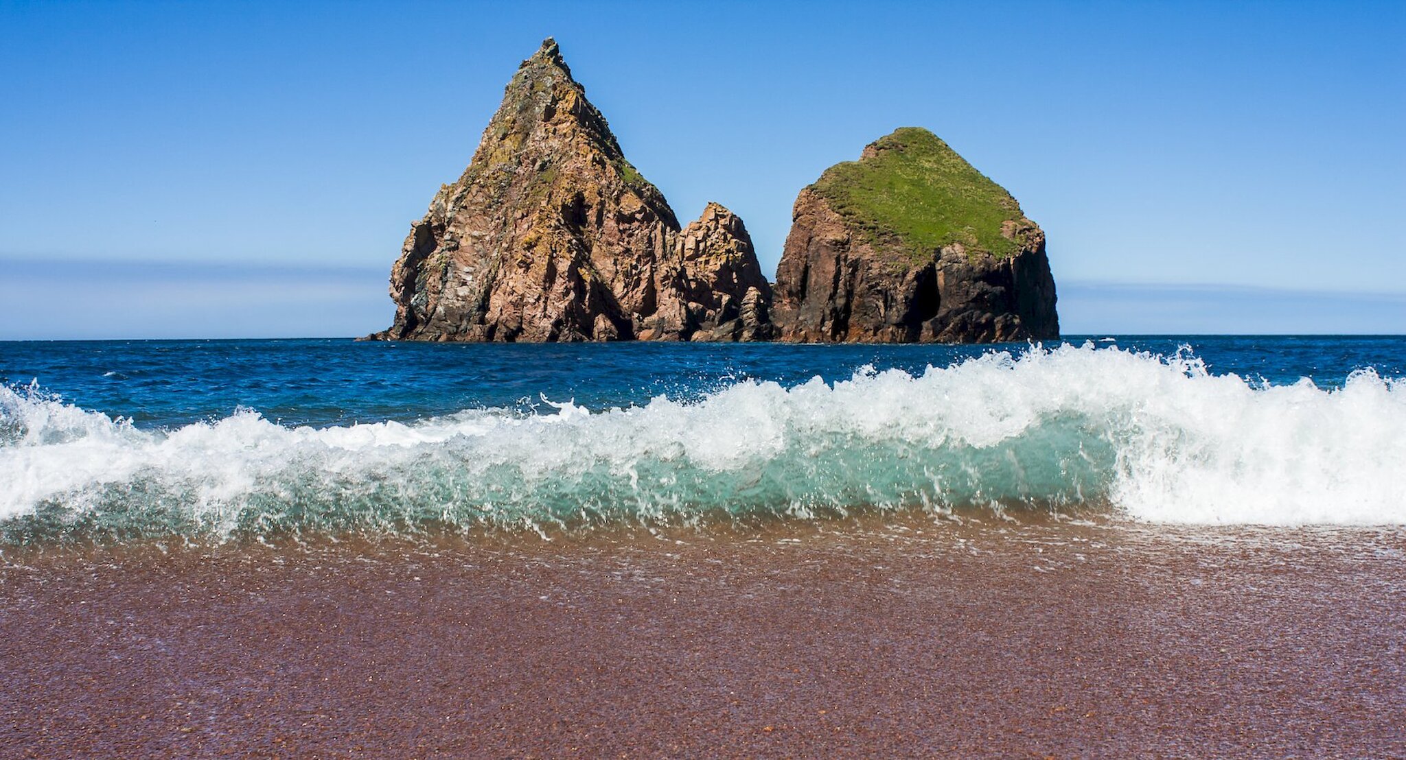
Best Beaches? As you may be aware, there are many candidates in that highly competitive Best Beaches in the World category. Upstarts such as Bondi, Sandwood Bay, Copacabana, Nairn. Forget all that. The best beaches of the world are all in Shetland. The South Mainland has the golden fineness of Spiggie, Boddam and especially the stunning tombolo, or double-sided beach, at St Ninian’s Isle (which possesses flattened pebbles so wondrous I once considered selling them on eBay in packs of four, to aid meditation. Or skimming.). The East and West Ayres at Hillswick have their charms, but things get really interesting when you hit the red granite that gives the northern part of the North Mainland its various names: North Roe, Ronas Hill, Roer Water. Red, red, red. Hidden away beneath some of the fractured, cave-pocked cliffs of Eshaness lie gritty shingle strands, only reachable via dodgy scrambles down ever-shifting watercourses for which you should really bring ropes, helmets and years of experience. But, in my case, never do. Fear of the embarrassment which would be involved in calling out the local coastguard, every man and woman of which is a friend or neighbour, mean that you simply cannot get stuck, get hurt or go missing. It is Not Allowed.

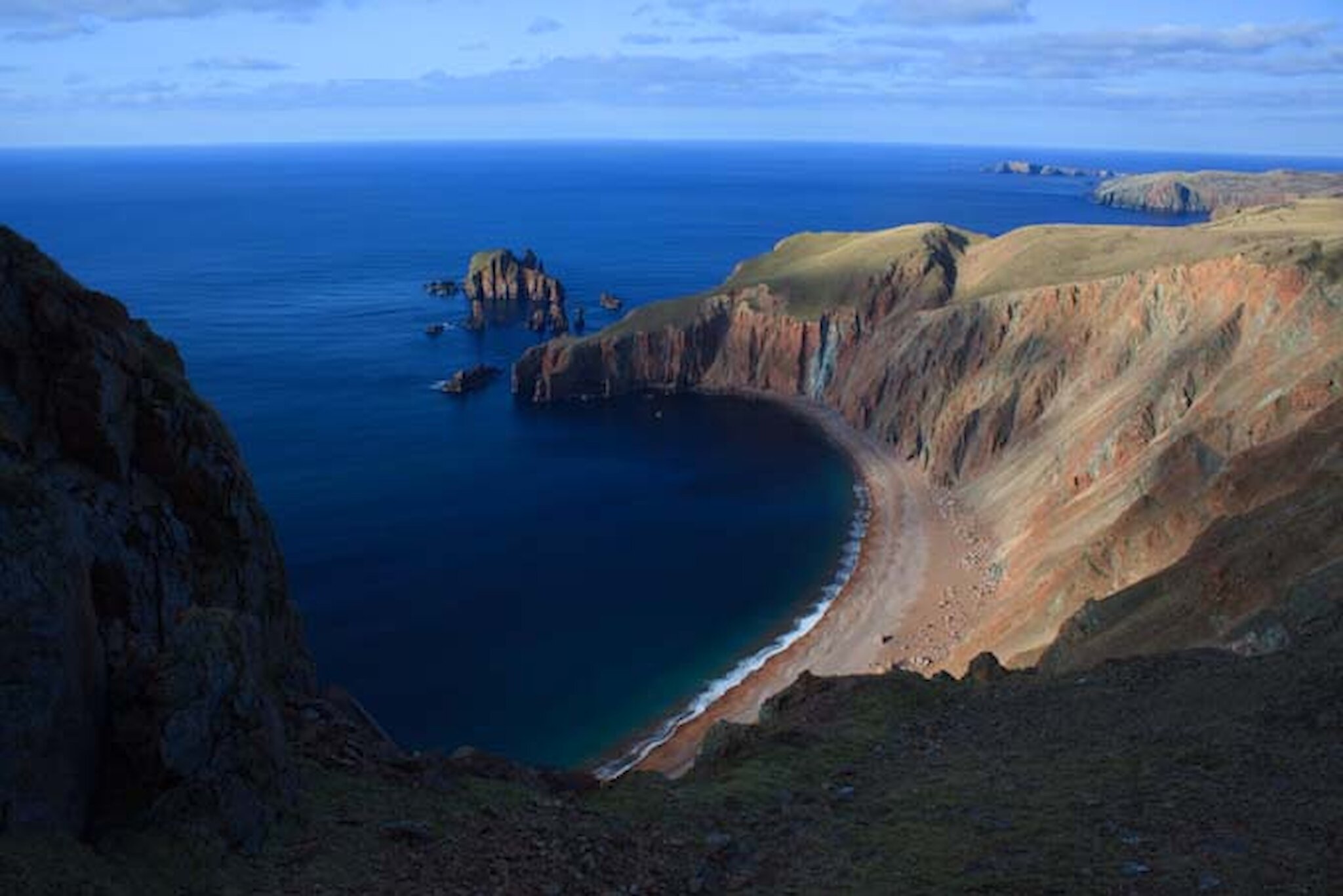
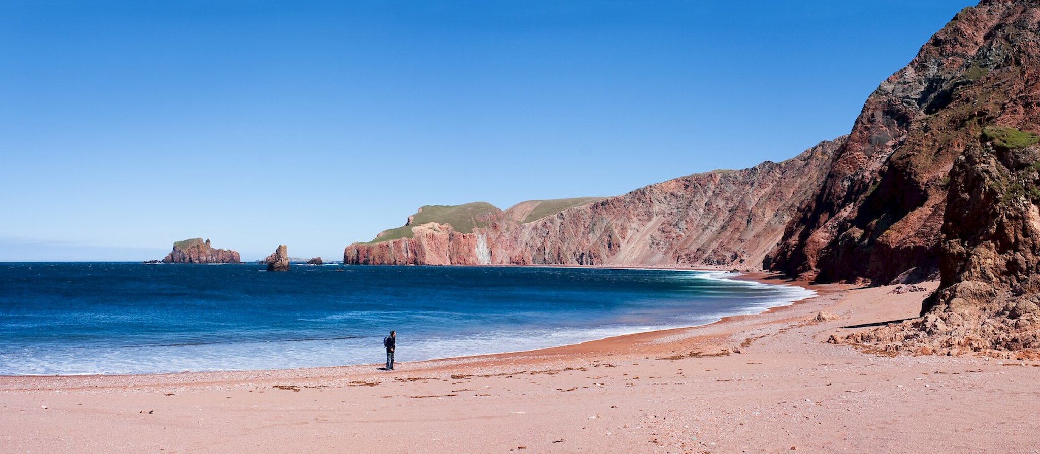
The two best beaches in Shetland – or, let’s be fair, my favourites – and hence in the world, are the Lang Ayre ('Long Beach') and the small tombolo at Uyea Isle. The Lang Ayre can be reached only be sea or by a long walk either over the top of Ronas Hill, Shetland’s highest peak, or along its Specially Scientifically Interesting flank. Uyea Isle lies about six miles to the north of the Lang Ayre. Uyea itself is an old crofting township, now inhabited only during the lambing season but containing some of the most fertile land in Shetland. There’s a drivable track from North Roe, grant-aid widened in places to almost motorway dimensions. It corkscrews through the Beorgs of Uyea and past such wondrous Norse nomenclature as Heogel of the Moor and Moosa Breck. No Gaelic here. Uyea, when reached from this route, appears like a green mirage, truly magnificent, a kind of scoured Shangri-La with extra sleet.

The track...corkscrews through the Beorgs of Uyea and past such wondrous nomenclature as Heogel of the Moor and Moosa Breck

The summer was fading, and my ambition was to walk from the old NATO station at Collafirth Hill across Ronas Hill, down to the Lang Ayre, and, as instructed by Squadron Leader Peter Guy, author of Walking the Coastline of Shetland, camp at Lang Clodie Wick. Then a morning’s walk to Uyea and out by the track, there to be collected at the North Roe phonebox. It’s 20 very rough and totally isolated miles. No mobile phone signal, once you’re out of sight of the Collafirth masts. There are hidden drops, pits and bogs. And if the weather gets frisky, you don’t want to be there. This is home to the UK’s highest windspeeds: a gust of over 173mph was recorded at Muckle Flugga lighthouse on 1 January 1992, before the equipment broke. Two tourists were killed in that storm when the hut they were staying in blew away. In 1962, 177mph was recorded at the radar dome on top of Saxa Vord in Unst – and then the apparatus was ripped apart. The official UK record remains 173mph on Cairn Gorm in 1986; their equipment seems to be more solidly anchored.

Anyway. You really don’t want to be walking “da banks” of the Lang Ayre any time between October and February, and you most certainly don’t want to be camping. Even in summer, weather is an obsession for Shetlanders. And, in this case, for me – a soothmoother, someone who arrived through the South Mouth of Lerwick Harbour.

As it happened, the forecast was for dullness, dreichocity and saturation, but not excessive blowing. And so Saturday lunchtime saw me dropped off at Collafirth by my son, who thinks I am mad. I certainly look mad, rucksacked-up with a Quechua one-man pop-up tent, light enough at two kilos but in its ineffable, green circularity making me look like a middle-aged Mutant Turtle.

The walk from the masts at Collafirth Hill to the top of Ronas Hill took about two hours. This scarred granite bounder field is often compared to the sub-arctic tundra of northern Norway. The existence of a neolithic chambered cairn (somewhat modified since the 1960s, but still very impressive), 40 metres below at the summit, never fails to give me the creeps, especially if up here in mist. Trowies (Shetlandic troll-Picts) infest the corners of your eyes. Still, it’s worth squirming in to see if the “ritual objects” that occasionally appear here have been nicked. Confront the creepiness!

The forecast was for dullness, dreichocity and saturation, but not excessive blowing

Onwards, though, to the Best Beach in Britain. And the Lang Ayre, when reached, viewed from the Stonga Banks or after an occasionally intimidating scramble down the smashed granite course of the Burn of Monius, was truly breathtaking. A mile-and-a-half of red shingle, backed with cliffs that give every impression of imminent crumbling. There are caves, infinite amounts of scran (beachcombing assets) and, offshore, the monstrous gothic-perpendicular stacks of the Cleiver and the Hog. Now there was a choice. To trudge along the strength-sapping shingle and trust the (surely no longer safe) standing rope at Turls Head to get back to the clifftop. Or scramble back up the burn. Long-left ropes attached to dubious spikes don’t appeal to me. I only knew about the rope (I couldn’t find it from the top) because a far fitter friend, walking alone, used it a couple of years ago, despite a halfway-up panic attack. Hereabouts, though, as an Eshaness pal is fond of saying about his home, there’s nobody to hear you scream.

Further up and furtherin, as another mile of beach-scimitar curves below the Valla Kames. There are some treacherous fissures and bottomless holes hereabouts, but the ground is largely firm. Inland, there are dozens of small lochs and some very mire-ridden sections on the short route out to the reservoir at Roer Water; at Lang Clodie Wick, where all the available water empties itself down two of the most spectacular waterfalls in Shetland, the short springy heather and rocky outcrops surrounding the death-black loch provide a dry and sheltered spot for camping. Indeed, it’s probably the best camping location in the whole of Shetland. There’s fresh water, shelter, astonishing views. There’s also a truly odd, stone-lined and slab-roofed pit which Squadron Leader Guy ruminates may be all that remains of a “a Neolithic motel”. But it was too early to stop, really, so I pressed on. I’m not afraid of ghosts. Honest.

On Hevdadale Hill, after an almost total absence of both fences and sheep, both began to make their presence felt. The Woolly Gods were back. I was getting sore and hungry, and though I could have pressed on and camped on the flatlands of Uyea, I opted for the amazing little canyon through which the Burn of Brettoo reaches the Red Geo, just along from Tongan Swarta. Feet washed in the fast-flowing, brutally cold water, I established my temporary home. The tent popped up and properly pegged out (who ever knows what the wind will do?), the Trangia was lit and, for a couple of hours before the sun drifted slowly into the north Atlantic, I entered that meditative state of pleasantly uncomfortable knackeredness that is solo overnighting. Old Pulteney 12 helped: a salty, outdoors whisky if ever there was one.

All the remains of a Neolithic Motel...

Curious sheep disturbed me during the short night. In the utter darkness, the stars arced, massive and soft, haloed like Christmas decorations. I got up in dampish, billowing weather and packed quickly. Bad rain was fluttering in the air.

Signs of cultivation and modern crofting increased: quad-bike tracks, new fences. But there was not a soul around as I reached Uyea and trekked for what seemed like miles across the runway-like pasture to the isle itself. The morning was closing in fast: grey, cold, wet. The tombolo joining the island to the mainland is tiny compared to the huge strand at St Ninian’s Isle, but it’s a jewel. Second-best beach in Britain? There are stories of Dutch East Indiaman gold in that sand, just as there are horrid tales of pirate murders just a bit north towards Sandvoe. There is one campsite the superstitious should avoid, where one buccaneer was buried alive, leaving only his head exposed to the predatory bonxies.

The climb out of Uyea on the track (suitable for 4x4s, but get Maurice’s permission first; access is always open for walkers and mountain bikers) seemed endless. As the road veered in and out of the Beorgs of Uyea, the cairns showing the site of a Neolithic axe factory were visible on the skyline. I was too tired and my ancient knees were too creaky to attempt the climb, but I wondered if there were any axe heads left. My wife claims to have seen dozens when she was last here 20 years ago, and items quarried here have been found all over Europe.

North Roe, finally. Still no mobile-phone signal, and the red phonebox is a mile along the main road from the track-end, next to the sadly closed shop. By the time I get there, icy rain is pummelling down, sideways and around, in the classic Shetland fashion. I called Susan. She would be here in 20 minutes.

Squatting on my rucksack, I read the Squadron Leader’s quotation of his fellow RAF man, Derek Gilpin Barnes, stationed at RAF Sullom Voe during the second world war and a keen explorer of the local landscape: “Did the brooding spirits of the ancient gods whisper to my companions as they did to me? Was that thin silence shattered in the quiet of their minds, by the clash of remote Scandinavian swords or the grinding of Norse keels upon those forgotten sands?”

Or is that the rattle of a Toyota Landcruiser’s turbo diesel, coming to whisk me home for the winter? Not very far away at all. By car.

OS Explorer 469: Shetland – Mainland North West, North Roe and Sullom Voe. Pictures and more about Tom’s walk can be found on his blog: http://beatcroft.blogspot.com/2009/08/into-wildernessand-out.html